 |
Headquarters
74 High Street
Billericay
Essex CM12 9BS
Affiliated to the Campign for
the Protection
of Rural Essex |
|
| |
| |
|
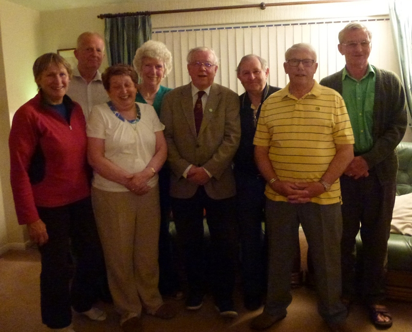
Photo from right to left, Lesley Humphries,
Bob Reeves, Julie Smith, Lynne Beard, David Bremner, John Humphries, Doug
Smith and Ian Fuller, and not forgetting all those who help out in the
background. |
| |
| It’s our 200 edition
so I thought it would be nice to see a photo of the Billericay Society
committee members who work very hard throughout the year to keep out society
ticking over. There are four people missing from the photo: Janet &
Peter Warren who run our raffle, Marian Thilo who organized our excellent
speakers and refreshments for the monthly meeting, and Mike Yates who
puts the Newsletter onto the World Wide Web.
The Billericay Society was formed on Saturday, 27th July, 1935. At that
time, the Council for the Protection of Rural Essex wanted to set up a
local area committee, so a meeting was held in Lockers Hall, and the first
President was Mrs Ward, owner of the Hall.
Consequently, The Society was then known as ‘The Billericay Area
Group of the Essex Branch of the Council for the Preservation of Rural
England’. The first Secretary was Basil Brooks, J.P.
It was long felt that such a title was unwieldy, and so in 1972 the name
was changed to “The Billericay Society”, affiliated to the
Council for the Protection of Rural Essex.
Following the death of Mrs Ward, the Earl of Mexborough (who lived in
Stockwell Hall, Little Burstead) took over as President in 1943. |
|
Walking on the wild side of life
|
|
Walking and reporting on the state of our local footpaths has been a popular
activity for members of the Billericay Society for 80 years and a regular
feature of the Newsletter.
The Greek physician Hippocrates said: Walking is man’s best medicine.
Early history of footpaths
Modern footpaths are the narrow trodden paths that may have originated
in antiquity. They were routes tramped by early man criss-crossing the
landscape as hunter-gatherers.
Once our hunter-gatherer ancestors had settled in one place and adopted
farming, their regularly walked paths, were the basis for modern footpaths.
The routes that our ancestors used to drive their cattle to their cattle
pens were called “drove roads” – now, on modern maps
called “Green Lanes”. These can be identified by roadways
having a ditch on either side with hedgerows to contain the cattle.
Another source of early routes, are the “salt roads”, used
to carry the salt from salt production areas, such as Maldon, to the many
manor houses. The areas where the salt was evaporated from sea water are
known as “red-hills”.
Modern footpaths now appear on Ordnance Survey maps. Especially:
The Explorer series at a scale of 1:25,000 or 4 cm to 1 km. In imperial
measure 2.5 inches to 1 mile; for the most detail of the countryside or:
The Landranger series at 1:50,000 at a scale of 2cm to 1 km. or 1.25 inches
to 1 mile, giving a much broader picture of the countryside.
Types of Public Right of Way paths, PRoW.
Today there are three categories of Public Right of Ways [PRoWs] giving
one access to the countryside - defined as:
- FOOTPATHS – a right to use the path on foot only – way marking
arrow sign is yellow.
- BRIDLEWAYS - a right to use the path on foot, horseback and pedal cycle
– way marking sign is a blue arrow.
- BYWAYS - a right to use the way by all of the above modes, plus the
right to drive horse-drawn and motorised vehicles along it – way
marking sign is a red arrow.
- There are also permitted paths that farmers allow one to use. But, these
can be withdrawn by the farmer.
- (The farmer may allow walkers to cross their fields for free, but the
bull may charge!)
Footpaths do not just happen, there are a number of rules governing them.
If a foot path is on a DEFINITIVE MAP it is conclusive evidence in law,
that it is a Public Right of Way.
The first provisional Definitive Map for Essex was prepared in 1953.
A review map was prepared in 1963 & published in 1970.
The ESSEX Definitive Map & Statements show all the Public Rights of
Way {PRoW} in Essex and is a legal document maintained by Essex County
Council, ECC.
A copy of this map is held by the Town Clerk.
Once a PRoW has come into existence it cannot be moved [“diverted”]
or closed [“extinguished”] except by formal order.
Other types of country paths are identified by the initials: CRF; &
RUPPs.
· CRF – Combined Road and Footpath – replaced by:
· RUPPs = Roads Used As Public Paths. These were reclassified in
1971 as:
· BOAT – Byway Open To All Traffic.
In 2006 Rupp s were re-classified as restricted byways with a purple way
marker.
This new class of way, is available to people on foot, horseback, pedal
cycle and horse drawn carriage.
By law, all PRoWs should be sign posted where they leave a proper road.
Billericay Society Footpath map 1960.
In 1966 the Billericay Society published a Billericay Footpath Map showing
and listing all of the footpaths in the Billericay countryside and town.
Foot paths in the listing: 1,3 – 21, 23, 25-28, 30-31, 33-52,54-65,
67, 69-72, 74, 79, 157, 160, 164, 166, 168, 187, 200, 202.
· These footpaths, their start & finish, are defined in six
pages in: Basildon District Definitive Statement for: Billericay dated
01/07/02.
Despite all of these rules for footpaths and government promises to protect
the Green Belt for the health, improved quality of life benefits, recreation
and safety of residents,modern flawed planning rules are ignoring these
promises.
Instead they want to cover the Green Belt and local farmland with houses.
Once this land is lost to developers it cannot be reclaimed. We may starve
in the future, but we will have lots of concrete covering the landscape.
So more floods will be possible.
There is no associated mention of improved infrastructure, such as roads,
medical centres, schools, parking facilities etc needed for a community
to function effectively.
Where are these people going to work? The trains to London are already
overcrowded.
3,000 houses means n x 3,000 extra cars blocking the roads, where will
they park for the station?
The planners are not going to live here.
If we are reducing illegal immigration and controlling general migration
to Britain – why do we still need all of these houses based on estimates
made long ago?
Planners have invested in expensive developments for rich foreigners,
who do not occupy these buildings. These should be used by those requiring
accommodation.
The planners should remember what happened in 1381, when the peasants
revolted.
On a lighter note. Walkers come in various categories or the Ages of Walkers:
The very young: “pramblers”
Then youngsters: “scramblers”
Teenage “shamblers”
Then energetic “ramblers”
Followed by “amblers” and for the very old, there are “gamblers”
David Bremner
|
| 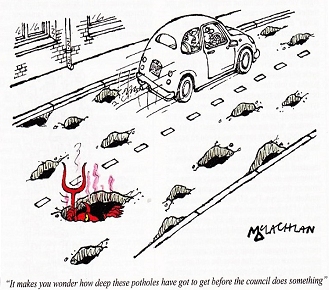
AN ABUNDANCE OF HOLES
A Local Councillor in Burton Staffordshire played Crazy Golf on
a major Road to emphasize the point of the danger to traffic due
to the potholes. In this, Billericay is fast becoming a close second
with its minor roads due to potholes increasing in size, depth and
abundance.
The weather this winter has seen an unusual amount of snow and ice.
Thus increasing the amount of pot holes, to use a religious term
a multitude has appeared from nowhere over a month or two. Local
roads, which make up 98% of the network are maintained by councils
who have had their budgets cut by more than a quarter since 2010.
I would hope that any locals would report any major holes and be
extra careful when dodging them to watch for oncoming vehicles.
A classic case in point is the intersection of Brightside Road and
Mountnessing Road. People, who are walking to the station or the
factories are parking their cars on the right hand side as you enter
Brightside. The pot holes are a major issue on the other side. Thus
making all cars bump over the pot holes. As many drivers do not
slow down when entering Brightside there have been many near misses
with cars trying to leave Brightside. Let alone the poor cyclists.
The condition of Billericay’s roads are deplorable. Another
example is Crescent Road where a deep and wide pot hole is situated.
It is now big enough to plant an array of flowers. One of the worse
examples is Perry Street after Orchard Avenue which is now like
a war zone. (Crazy golf could easily be played there).
In time the only good roads in Billericay will be the ones connected
to the new housing estatesThe filling of pot holes is really only
a temporary solution. What is needed is for roads to be resurfaced,
which unfortunately is unrealistic when funds are not available.
Do you remember what we were informed our Car Tax would be used
for?
The upkeep of our roads. “YEA RIGHT”!!!!!
Doug Smith Vice Chairman
|
I included this as a matter of interest from the BDRA Newsletter.
Bob Reeves
|
Please check with walk leader in case of any changes. John H: 656527
(Due to the uncertainty of numbers of walkers. We will not be booking
seats in pubs.)
12th June CANCELLED walk DAB has Achilles tendon problem
26th June Thorndon South Half Way House CM13 3LL 811235 John Humphries
to lead
10th JulyBicknacre/Danbury Brewers Arms 01245 224061 Grid Ref 183/788
022John H to lead
24th July Fobbing White Lion 01375 673281 SS17 9JRDavid – if better!
7th AugustCancelledno leader available.
21st August Chipping Ongar Two Brewers p95 .50 Walks CM5 9HD 362445John
H to lead.
4th Sept Stock, Bakers Arms, CM4 9NF. 01277 841831. David
18th Sept North Weald Bassett Kings Head 01992 525001.John H to lead
Sept 2018 - Sorry, no further walks are to be organised.
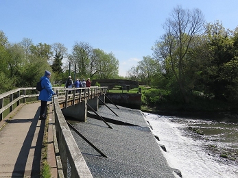
On a unique, dry sunny day, on the 1st May with a light breeze, seven
members of the walking group enjoyed a refreshing walk to Beeleigh Abbey
and falls, returning by the bank of the Chelmer Navigation Canal.
After a long period of heavy rains of April the Chelmer Canal was in full
flood, over flowing the lock gates, as it merged with the river Blackwater,
the noise from the weirs made fantastic listening.
An added attraction was a chap checking a Jaguar X16, an open top old
sports car in Bentley racing green. Many photographs were taken of the
car and falls. Luncheon was at the Fig Tree Café in Maldon High
Street. We are trying cafes for luncheon as the pubs are sadly closing
Photo by Norman Hunter
David Bremner
 Bob
Reeves Newsletter Editor. Bob
Reeves Newsletter Editor.
We wish to apologise to those of you who turned up at the monthly meeting
on the 23rd May instead of the 16th this was a printing error in the yearly
programme, we tried to tell as many folks as possible.
| |